More About Plumecast
Plumecast is fast
Because the model runs continuously information is available instantly, literally instantly. A map of the risk area can be displayed anytime, even there is no incident in progress.
Plumecast is accurate
Because Plumecast uses real data it does not rely on estimates of atmospheric turbulence. Neither does it rely on wind data read manually from a dial or wind data from a compter model wind field.
Plumecast is compatible with other systems
Plumecast generates files in KML format marking risk areas. These are compatible with widely used GIS systems.
Plumecast is safe
Plumecast is unique in that it plots a risk area with no assumptions about the nature or concentration of released material. This is very important. In the early phase on an incident the amount of material released, or even what is released, will be unknown. Other systems model a distribution of material in the air and make an assumption that when this has fallen to a given fraction of peak then the area is safe. This is an unwarrantied assumption. Plumecast risk areas are therefore wider in order to give confidence to responders in the early stage of an incident.
Plumecast gives extra information
Plumecast provides information on the rate of plume spread.
This tells responders how far material will travel in a given time.
Plumecast can display where a plume has already spread.
Plumecast has been thoroughly tested.
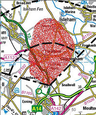
It has been installed successfully at H.W.Coates Ltd., a COMAH Top-Tier site in Cambridgeshire, UK
"H.W. Coates Ltd is pleased with Plumecast which we have incorporated into our off-site emergency plans and procedures.”
Ashley Harriman
Operations Manager, H.W. Coates, Newmarket, UK
For commercial enquiries contact R-P-R Ltd: -
Richard Paul Russell Ltd.
The Lodge
Unit 1 Barnes Farm Business Park
Barnes Lane
Milford on Sea
SO41 0AP
Tel: +44 (0)1590 641223